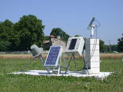
The AErosol RObotic NETwork (AERONET) is a federated network of ground-based remote sensing aerosol sensors established in 1993 by NASA and the PHOtométrie pour le Traitement Opérationnel de Normalisation Satellitaire (PHOTONS). Each AERONET site includes a CIMEL Electronique sunphotometer that measures solar irradiance and sky radiances. These measurements are used to determine aerosol properties, including aerosol optical depth and extinction. The sunphotometers operate at nine wavelengths (340, 380, 440, 500, 675, 870, 937, 1020, and 1640 nm) and provide aerosol data approximately every 15 minutes. AERONET sites are distributed worldwide, enabling mapping of about 90% of the Earth’s surface.

Instrument Details
- Optical/Photon
- Earth Science > Atmosphere > AerosolsEarth Science > Atmosphere > Aerosols > Aerosol Optical Depth/thicknessEarth Science > Atmosphere > Aerosols > Aerosol RadianceEarth Science > Atmosphere > Atmospheric Radiation > Solar IrradianceEarth Science > Atmosphere > Aerosols > Aerosol ExtinctionEarth Science > Atmosphere > Aerosols > Aerosol Particle Properties
- Land Surface, Troposphere
- 15 min
- Variable
- 183-882 THz
- https://aeronet.gsfc.nasa.gov/new_web/system_descriptions_calibration.html
Pawan Gupta, Elena Lind
Mikhail Sorokin, Jason Kraft
CIMEL Electronique
NASA
other NASA repository not formally considered a DAAC by ESDS
Filter data products from this instrument by specific campaigns, platforms, or formats.
